The Scotia Sea and Scotia Arc: A Critical Ocean Gateway and Geological Barrier
The Scotia Sea is an ocean region between South America and Antarctica. It connects the Atlantic and Pacific Oceans and is critical in global ocean and climate systems. The Scotia Arc is a curved line of underwater ridges and islands that influences the distribution of marine life and ocean currents.
 via Wikimedia Commons")
, Alfred Wegener Institute for Polar and Marine Research, Bremerhaven, Germany (CC BY-SA 3.0) via Wikimedia Commons")
 in Salisbury plain on South Georgia - via Wikimedia Commons")
 https://www.flickr.com/photos/14417999@N00/447437728")
 via Wikimedia Commons")
 via Wikimedia Commons")
The Scotia Complex: Bridging Continents and Oceans in the Southern Hemisphere
Tucked away in the remote waters between South America and Antarctica lies a remarkable ocean region known as the Scotia Sea. This dynamic body of water plays a critical role in global ocean and climate systems, acting as a crucial gateway between the Atlantic and Pacific Oceans. Surrounding the Scotia Sea is the Scotia Arc, an arc-shaped submarine ridge and island chain that forms a biogeographic barrier, shaping the distribution of marine life and influencing the flow of ocean currents. The Scotia Sea and its bounding Scotia Arc represent a geologically and ecologically significant part of the world that continues to captivate explorers, scientists, and conservationists alike.
The Scotia Sea: A Critical Ocean Gateway
The Scotia Sea is a vast, dynamic ocean region between South America and Antarctica, covering an area of approximately 900,000 square kilometers (347,000 square miles). Named after the expedition ship Scotia, which explored these waters between 1902 and 1904, the Scotia Sea plays a crucial role in the global ocean and climate systems.
Defining the Scotia Sea
The Scotia Sea is bounded to the west by the Drake Passage, a critical link between the Atlantic and Pacific Oceans, and to the north, east, and south by the Scotia Arc, an arc-shaped submarine ridge and island chain atop the Scotia Plate. This region, located at the convergence of major oceanic systems, can be considered a transitional area between the Southern Ocean and the South Atlantic Ocean. Its southern portions, dominated by colder Antarctic waters and influenced by the Antarctic Circumpolar Current, are more definitively part of the Southern Ocean. Meanwhile, its northern regions experience a greater influence from subantarctic and Atlantic waters, highlighting its role as a bridge between these two dynamic marine environments. The Scotia Sea and its bounding Scotia Arc shape oceanic circulation by steering the Antarctic Circumpolar Current and fostering the mixing of water masses, enriching its biodiversity and productivity.
Geological Formation and Significance
The Scotia Arc results from a complex geological history formed by the fragmentation and drift of continental landmasses. Once a land bridge connecting South America and Antarctica, the Scotia Arc is considered a continuation of the Andes mountains, with the Antarctic portion known as the Antarctandes. The active volcanic arc-trench system at the eastern end of the Scotia Arc, including the South Sandwich Islands, is geologically comparable to the Lesser Antilles Volcanic Arc in the Caribbean Sea.
The Scotia Sea and its surrounding region are crucial in global ocean and climate dynamics. As a gateway between the Atlantic and Pacific Oceans, the Scotia Sea influences the flow of the Antarctic Circumpolar Current, one of the most powerful ocean currents in the world. This current helps drive the global ocean circulation system, transporting heat, nutrients, and other essential components around the planet.
Biodiversity and Ecology
The islands and waters of the Scotia Sea support diverse flora and fauna adapted to the region's challenging environmental conditions. The rocky, ice-covered islands are home to tundra vegetation, including mosses, lichens, algae, and a variety of seabirds, penguins, and seals.
Seabird species in the Scotia Sea region include several albatross species, such as the black-browed albatross, grey-headed albatross, light-mantled albatross, and the iconic wandering albatross. Other seabirds include the southern giant petrel, which has sizeable colonies on islands like Bird Island. Penguin species in the area include the king penguin, chinstrap penguin, macaroni penguin, gentoo penguin, Adélie penguin, and rockhopper penguin.
The surrounding waters are also home to diverse marine mammals, including Antarctic fur seals, sub-Antarctic fur seals, leopard seals, Weddell seals, southern elephant seals, and crabeater seals. These animals rely on the rich marine ecosystems supported by the Scotia Sea's unique geographic position and oceanographic conditions.
Exploration and Research
The remote and challenging nature of the Scotia Sea region has long captured the interest of explorers and scientists. Early expeditions, such as the Scotia voyage in the early 20th century, helped map and document the region's geography and natural history. Today, the Scotia Sea remains an essential site for scientific research, with studies focusing on topics ranging from oceanography and climate change to marine ecology and the impacts of human activities.
Ongoing research in the Scotia Sea region is crucial for understanding the complex interactions between the ocean, atmosphere, and cryosphere and the delicate balance of the region's unique ecosystems. As a global climate regulator and biodiversity hotspot, the Scotia Sea and its surrounding features remain an area of intense scientific interest and conservation concern.

Map of the Scotia Sea, including undersea relief, maritime, nearby lands, countries and cities.
The Scotia Arc: A Geological and Biogeographic Barrier
The Scotia Arc is the submarine ridge and island chain that forms the northern, eastern, and southern borders of the Scotia Sea, surrounding the small Scotia and South Sandwich tectonic plates. This arc-shaped feature plays a vital role in shaping the region's geography, oceanography, and ecology of the region.
Geological Components of the Scotia Arc
The Scotia Arc comprises several distinct geological features, including:
The North Scotia Ridge: Stretching from the tip of Tierra del Fuego to the South Sandwich Islands, this ridge includes Isla de los Estados, the Burdwood Bank, Davis Bank, and Aurora Bank, as well as South Georgia Island and the Clerke Rocks.
The South Sandwich Islands: This volcanic arc of small, remote islands lies east of the South Sandwich Trench, a deep oceanic trench.
The South Scotia Ridge: Extending from the South Sandwich Islands to the Antarctic Peninsula, this ridge includes Herdman Bank, Discovery Bank, Bruce Bank, Pirie Bank, Jane Bank, the South Orkney Islands, and Elephant Island.
The Scotia Arc formed as a result of the fragmentation and drift of continental landmasses. The Bransfield Strait separates the arc from the South Shetland Islands and James Ross Island near the tip of the Antarctic Peninsula.
Biogeographic Significance
The Scotia Arc plays a crucial role in the region's biogeography, acting as a barrier between the Pacific and Atlantic Oceans. This barrier influences the distribution and migration of marine species, the flow of ocean currents and the transport of nutrients and other essential components.
The islands and banks of the Scotia Arc support diverse ecosystems, including tundra vegetation, seabird colonies, and breeding grounds for various seal species. These remote, often ice-covered islands provide critical habitat for species adapted to the harsh environmental conditions of the sub-Antarctic and Antarctic regions.
The Scotia Arc also serves as a dispersal corridor for some species, facilitating gene flow and population connectivity between South America and Antarctica. This biogeographic link is fascinating to scientists studying the evolution and distribution of Antarctic and sub-Antarctic biota.
Conservation Challenges
The remoteness and fragility of the Scotia Arc's ecosystems make them particularly vulnerable to the impacts of climate change, pollution, and other human activities. Melting glaciers, rising sea levels, and changes in ocean currents and temperature can all threaten the delicate balance of these ecosystems.
Additionally, the increasing human presence in the region through activities such as tourism, fishing, and scientific research can also pose challenges to conservation efforts. Careful management and international cooperation are essential to protect the unique and valuable ecosystems of the Scotia Arc.
Overall, the Scotia Sea and the Scotia Arc represent a critical yet fragile interface between the Atlantic and Pacific Oceans, with immense geological, oceanographic, and ecological significance. Continued research and conservation efforts in this remote and dynamic region are crucial for understanding and preserving its global importance.
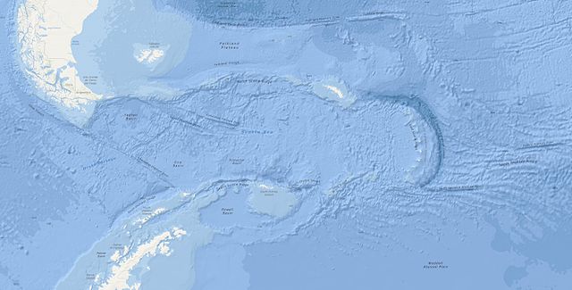
Topographic map of the Scotia Sea and Scotia Arc: NOAA.