The Geography of Paraguay: A Landlocked Nation at the Heart of South America
Paraguay occupies a unique position in South America as one of only two landlocked countries on the continent, along with Bolivia. Located in the south-central part of the continent, the country's strategic position has significantly influenced its history, economy, and cultural development.


 https://www.flickr.com/photos/caneladeurubu/488773496")


From the Paraná to the Chaco: A Geographic Analysis of Paraguay
Paraguay occupies a unique position in South America as one of only two landlocked countries on the continent, alongside Bolivia. Situated in the south-central portion of the continent, Paraguay covers an area of approximately 406,752 square kilometers (157,048 square miles), making it roughly the size of California. This compact nation serves as a geographic bridge between the more developed southern regions of South America and the tropical northern areas, creating a distinctive physical and cultural landscape that reflects both temperate and subtropical influences.
The country's strategic location has profoundly shaped its history, economy, and cultural development. Bordered by Brazil to the east and north, Bolivia to the northwest, and Argentina to the south and west, Paraguay sits at the confluence of major river systems, serving as a natural crossroads for regional trade and migration patterns. Despite its landlocked status, Paraguay maintains vital connections to the Atlantic Ocean through the Paraguay-Paraná river system, which has served as the nation's primary transportation corridor since colonial times.
Physical Geography and Topography
Paraguay's topography is characterized by gentle undulations rather than dramatic elevation changes, with most of the country lying between 200 and 600 meters (656 and 1,968 feet) above sea level. The highest point in the country is Cerro Peró, located in the Cordillera Department, which reaches an elevation of 842 meters (2,762 feet) above sea level. The lowest elevation is located along the Paraguay River, near the Argentine border, at approximately 46 meters (151 feet) above sea level.
The Paraguay River, flowing north to south through the country's center, serves as both a natural transportation route and the primary geographic divide that separates the nation into two distinct regions. This river system, part of the larger Río de la Plata basin, effectively bisects the country into eastern and western halves, characterized by markedly different physical characteristics, climate patterns, and population distributions.
The eastern region, known as the Región Oriental, spans approximately 159,827 square kilometers (61,710 square miles), accounting for about 39% of the national territory. This area is characterized by rolling hills, fertile plains, and scattered low mountain ranges that form part of the Brazilian Highland system. The landscape features a series of parallel ridges and valleys running generally north to south, with elevations gradually increasing toward the Brazilian border. These uplands, locally referred to as cordilleras, form natural watersheds that direct drainage toward both the Paraguay River system and the Paraná River, along the southern and eastern borders of the region.
The western region, known as the Región Occidental or Chaco, spans approximately 246,925 square kilometers (95,338 square miles), accounting for about 61% of Paraguay's territory. This vast plain extends westward from the Paraguay River to the borders with Bolivia and Argentina, forming part of the larger Gran Chaco ecosystem that spans portions of four countries. The Chaco is characterized by extremely flat topography, with elevation changes of only a few meters over distances of hundreds of kilometers. This subtle topography creates a complex pattern of seasonal flooding and drainage that significantly influences both natural ecosystems and human settlement patterns.
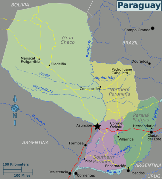
Map depicting the geographic regions of Paraguay.
Climate and Weather Patterns
Paraguay experiences a subtropical climate characterized by distinct wet and dry seasons, with regional variations influenced by latitude, elevation, and proximity to major water bodies. The country lies entirely within the southern hemisphere's subtropical zone, between approximately 19° and 27° south latitude, placing it in a transitional climate region between tropical and temperate systems.
Temperature patterns across Paraguay reflect both latitudinal and seasonal variations. Average annual temperatures range from about 24°C (75°F) in the northern regions to approximately 20°C (68°F) in the south. Summer temperatures, which occur during the southern hemisphere's summer months from December to March, frequently exceed 35°C (95°F), particularly in the northern Chaco region, where temperatures can reach 45°C (113°F) during heat waves. Winter temperatures, from June through August, are considerably milder, with average temperatures ranging from 15°C to 25°C (59°F to 77°F). However, occasional cold fronts from Antarctica can bring temperatures below 0°C (32°F) to southern regions.
Precipitation patterns exhibit both seasonal and regional variations that significantly influence the country's hydrology and agricultural potential. The eastern region generally receives between 1,200 and 1,800 millimeters (47 to 71 inches) of rainfall annually, with the highest amounts occurring in the eastern highlands near the Brazilian border. The western Chaco receives considerably less precipitation, typically between 500 and 1,200 millimeters (20 to 47 inches) annually, with amounts decreasing toward the western border with Bolivia.
The wet season, which extends roughly from October to April, accounts for approximately 70% of the annual precipitation. During this period, intense thunderstorms and occasional tropical systems bring heavy rainfall that can cause significant flooding in low-lying areas. The Paraguay River and its tributaries typically experience their highest water levels during these months, creating extensive wetlands and temporary lakes across the Chaco region. The dry season, from May through September, is characterized by clear skies, lower humidity, and minimal precipitation, creating conditions that can stress both natural vegetation and agricultural crops.
Hydrology and Water Resources
Paraguay's hydrological systems are dominated by the Paraguay-Paraná river basin, which drains virtually the entire national territory and provides the country's primary connection to international waterways. The Paraguay River, the nation's most important waterway, flows approximately 2,549 kilometers (1,584 miles) from its source in Brazil's Mato Grosso to its confluence with the Paraná River, with about 1,200 kilometers (746 miles) of its course passing through Paraguayan territory.
The Paraguay River serves multiple critical functions for the nation, including international commerce, domestic transportation, urban water supply, and ecosystem maintenance. The river is navigable year-round by ocean-going vessels as far north as Asunción, Paraguay's capital and principal port, making it a vital commercial lifeline for this landlocked nation. During the wet season, the river's flow increases dramatically, creating extensive floodplains that support diverse wetland ecosystems and provide natural flood control for downstream areas.
Major tributaries of the Paraguay River include the Pilcomayo, which forms a significant portion of the border with Argentina, and numerous smaller streams that drain the eastern highlands. The Pilcomayo River, originating in the Bolivian Andes, carries significant sediment loads that have created extensive alluvial deposits along its lower course, contributing to the characteristic flat topography of the Chaco.
The eastern region's hydrology is dominated by tributaries of the Paraná River, including the Monday, Acaray, and Jejuí rivers. These waterways have carved valleys through the eastern highlands, creating fertile bottomlands that support intensive agriculture. The Paraná River itself forms Paraguay's southeastern border with Brazil and Argentina, and its massive flow has been harnessed for hydroelectric power generation through projects like the Itaipu Dam, one of the world's largest hydroelectric installations.
Groundwater resources vary significantly between Paraguay's two main regions. The eastern region benefits from aquifers associated with the Guaraní Aquifer System, one of South America's most important groundwater resources. This massive aquifer system extends beneath portions of Paraguay, Brazil, Argentina, and Uruguay, providing high-quality water for both urban and rural populations. In contrast, the Chaco region's groundwater is often brackish or saline, limiting its utility for human consumption and agriculture.
Natural Regions and Ecosystems
Paraguay's position at the intersection of several major South American biomes creates exceptional biological diversity within its relatively small territory. The country encompasses portions of the Atlantic Forest, Cerrado savanna, and Chaco ecosystems, each supporting distinct plant and animal communities adapted to specific environmental conditions.
The Atlantic Forest ecosystem, locally known as the Mata Atlántica, once covered a significant portion of eastern Paraguay but has been substantially reduced due to agricultural conversion and urban development. Remnant forest patches in the eastern highlands contain extraordinarily high levels of biodiversity, including numerous endemic species found nowhere else on Earth. These forests are characterized by multiple canopy layers, dense undergrowth, and complex ecological relationships that have evolved over millions of years. Important tree species include valuable hardwoods, such as lapacho and cedar, as well as various palm species, which have supported both subsistence and commercial forestry activities.
The Cerrado ecosystem, extending into northern Paraguay from Brazil, represents a transitional zone between forest and grassland environments. This savanna ecosystem is characterized by scattered trees and shrubs adapted to seasonal drought conditions, with grasslands that support both wild herbivores and domestic livestock. The Cerrado has proven highly suitable for mechanized agriculture, particularly for soybean cultivation, resulting in extensive conversion of natural vegetation in recent decades.
The Chaco ecosystem dominates western Paraguay, representing one of South America's largest intact dry forest systems. This ecosystem is characterized by drought-tolerant trees and shrubs, seasonal wetlands, and extensive grasslands that support a diverse array of wildlife populations. The Chaco's plant communities have adapted to extreme seasonal variations in water availability, with many species capable of surviving extended drought periods followed by intense flooding events.
Paraguay's wetland ecosystems, particularly those associated with the Paraguay River and its tributaries, provide critical habitat for migratory waterfowl and support important fisheries. These wetlands expand and contract seasonally, creating dynamic ecosystems that support both aquatic and terrestrial species throughout different phases of the annual cycle.
Human Geography and Settlement Patterns
Paraguay's human geography reflects the profound influence of its physical environment on population distribution, economic activities, and cultural development. With a total population of approximately 7.4 million people, Paraguay maintains one of South America's lowest population densities, averaging about 18 people per square kilometer (47 people per square mile). However, this population is extremely unevenly distributed between the country's eastern and western regions.
Despite comprising less than 40% of Paraguay's territory, the Región Oriental contains approximately 97% of the national population. This concentration reflects the region's more favorable climate, fertile soils, better water resources, and historical patterns of colonial settlement. Population densities in the eastern region average about 45 people per square kilometer (117 people per square mile), with much higher concentrations around major urban centers.
Asunción, Paraguay's capital and largest city, exemplifies the concentration of population and economic activity in the eastern part of the country. Located on the east bank of the Paraguay River near the geographic center of the country, Asunción and its metropolitan area contain approximately 2.3 million people, roughly one-third of the national population. The city's strategic location at the confluence of several rivers has made it the natural center for commerce, government, and transportation throughout Paraguay's history.
The Región Occidental or Chaco, despite its vast extent, contains only about 3% of Paraguay's population, resulting in an average density of less than one person per square kilometer (approximately 2.6 people per square mile). This sparse population reflects the region's challenging environmental conditions, limited water resources, and historical isolation. Most Chaco residents are concentrated in a few small towns and scattered ranches, where they engage in extensive cattle raising and limited agriculture.
Rural settlement patterns throughout Paraguay reflect both environmental constraints and cultural preferences. In the eastern region, rural populations are distributed relatively evenly across the landscape, with most families residing on small to medium-sized farms that combine subsistence agriculture with the production of cash crops. Traditional settlement patterns emphasize nucleated villages surrounded by individual family plots, a system that facilitates social interaction while maintaining agricultural productivity.
Indigenous populations, representing about 2% of Paraguay's total population, maintain distinct settlement patterns and cultural practices that reflect their historical adaptation to local environmental conditions. Most Indigenous communities are located in remote areas of both the eastern forests and the Chaco, where they engage in various combinations of traditional subsistence activities and participate in the broader national economy.
Economic Geography and Land Use
Paraguay's economy remains heavily dependent on agriculture and natural resource extraction, activities closely tied to the country's geographic characteristics. The nation's landlocked position has necessitated the development of efficient transportation networks and trade relationships that overcome the challenges of distance from international markets.
Agriculture dominates land use patterns throughout eastern Paraguay, where favorable climate and soil conditions support both subsistence and commercial crop production. Soybeans have emerged as Paraguay's most important export crop, with production concentrated on large mechanized farms in the eastern and northern departments. The expansion of soybean cultivation has transformed vast areas of former forest and grassland into geometric patterns of cultivation that reflect modern agricultural technologies and global market demands.
Traditional crops, including corn, wheat, rice, and cotton, continue to play a crucial role in Paraguay's agricultural economy, particularly in meeting domestic consumption and supporting regional trade. Livestock raising, primarily cattle, occurs throughout both regions but follows different patterns in each. In the eastern region, cattle are typically integrated with crop production on relatively small farms, whereas the Chaco supports extensive ranching operations that cover thousands of hectares.
Paraguay's abundant water resources have enabled the development of one of the world's most important hydroelectric power sectors. The Itaipu Dam, shared with Brazil on the Paraná River, generates more electricity than Paraguay can consume, making hydroelectric power a major export commodity. Similarly, the Yacyretá Dam, shared with Argentina, contributes to both domestic energy supply and export revenues.
Forest resources, although significantly diminished from their historical levels, continue to provide important economic benefits through both timber extraction and the production of non-timber forest products. Sustainable forest management has become increasingly important as remaining forest areas face pressure from agricultural expansion and urban development.
The Chaco region's economy is primarily based on extensive cattle ranching, which leverages the region's natural grasslands and scattered forest resources. Recent discoveries of natural gas and petroleum deposits in the Chaco have created new economic opportunities while raising questions about environmental protection and Indigenous rights.
Environmental Challenges and Conservation
Paraguay faces significant environmental challenges that reflect the intersection of rapid economic development, population growth, and the need to preserve critical ecosystems. Deforestation represents perhaps the most serious environmental issue, with Paraguay experiencing one of the world's highest rates of forest loss during recent decades.
The conversion of Atlantic Forest ecosystems in eastern Paraguay has reduced original forest cover to less than 10% of its historical extent. This deforestation has led to the loss of biodiversity, increased soil erosion, and reduced watershed protection, ultimately affecting both local and regional water resources. Government efforts to establish protected areas and enforce environmental regulations have had limited success in slowing the rate of deforestation.
Agricultural expansion, particularly for soybean production, continues to pressure remaining natural ecosystems throughout the eastern region. The use of agricultural chemicals has raised concerns about water quality and soil health, while mechanized farming practices have contributed to erosion problems in areas with steep topography.
In the Chaco region, cattle ranching and recent oil exploration activities have created new environmental pressures on what was previously one of South America's largest intact dry forest ecosystems. Climate change projections suggest that the Chaco may become increasingly arid, potentially affecting both natural ecosystems and agricultural productivity.
Water resource management presents ongoing challenges, particularly in urban areas where rapid population growth has strained existing infrastructure. The Paraguay River, while providing abundant water resources, also serves as a receptacle for urban and industrial waste that affects water quality for downstream users.
Conservation efforts have focused on establishing protected areas, promoting sustainable land-use practices, and developing ecotourism as an alternative economic activity. The creation of national parks and private reserves has protected important examples of Paraguay's diverse ecosystems; however, enforcement and funding remain ongoing challenges.
Transportation and Regional Connectivity
Paraguay's landlocked position has made the development of efficient transportation networks essential for economic growth and international trade. The country's transportation infrastructure reflects both its geographic constraints and its historical development patterns, with most major routes connecting eastern population centers to international markets through neighboring countries.
The Paraguay-Paraná Waterway serves as Paraguay's primary transportation corridor, providing access to Atlantic Ocean ports via Argentina. This river system handles the majority of Paraguay's international trade, including agricultural exports and imported manufactured goods. River ports at Asunción and other locations along the Paraguay River connect the country's interior regions to global shipping networks.
Road networks in Paraguay radiate outward from Asunción toward border crossings with neighboring countries, reflecting the capital's role as the national transportation hub. The Trans-Chaco Highway, extending westward from Asunción to the Bolivian border, represents a significant engineering achievement that has opened previously inaccessible areas of the Chaco to development, while also providing an important regional trade route.
Railway infrastructure, once crucial for connecting Paraguay to Argentine ports, has lost significance as road transportation has become more flexible and cost-effective. However, recent discussions about rehabilitating rail connections reflect ongoing efforts to enhance transportation efficiency and reduce costs associated with bulk commodity exports.
Air transportation connects Paraguay to regional and international destinations through Silvio Pettirossi International Airport near Asunción. Domestic air services provide connections to remote areas of the country, particularly in the Chaco region, where road access remains limited.
Conclusion
Paraguay's geography presents a fascinating study in contrasts, ranging from the fertile hills of the east to the vast Chaco plains, and from densely populated areas to virtually uninhabited wilderness areas. The country's central location in South America has created both opportunities and challenges that continue to shape its development trajectory.
The Paraguay River's role as both a geographic divide and a unifying transportation corridor exemplifies the complex relationships between physical geography and human development. While the river separates the country into distinct eastern and western regions with different environmental characteristics and development patterns, it also provides the crucial link that connects Paraguay to international markets, maintaining the nation's economic viability despite its landlocked position.
Paraguay's environmental diversity, encompassing portions of three major South American biomes, presents exceptional opportunities for biological conservation and sustainable development. However, the pressures of agricultural expansion, urbanization, and resource extraction persist, posing a challenge to efforts to balance economic growth with environmental protection.
Looking toward the future, Paraguay's geography will continue to influence the country's development options and constraints. Climate change may alter precipitation patterns and temperature regimes, potentially affecting agricultural productivity and water resources. Urban growth is likely to continue concentrating in the eastern region, increasing pressure on infrastructure and natural resources, while leaving vast areas of the Chaco sparsely populated.
The challenge for Paraguay will be leveraging its geographic advantages, including abundant water resources, hydroelectric potential, and agricultural productivity, while addressing the constraints imposed by its landlocked position and the need to preserve critical ecosystems. Success in meeting these challenges will determine whether Paraguay can achieve sustainable development that benefits all its citizens while maintaining the environmental integrity that makes the country's geography so distinctive and valuable.
Understanding Paraguay's geography provides insights not only into this specific nation but also into the broader patterns of human-environment interaction that characterize South America's development. As one of the continent's smaller countries, Paraguay demonstrates how geographic factors can create both limitations and opportunities that profoundly influence national development trajectories and regional relationships.