The Geography of Colombia: A Land Where Andes Meet Amazon
Colombia is among the most geographically diverse countries on the continent. Its location at the junction of Central and South America provides an exceptional variety of landscapes, including towering Andean peaks, vast tropical rainforests, expansive grasslands, and extensive coastlines.
 https://www.flickr.com/photos/alvaroramirez/5657844895/in/album-72157626459759025/")


 https://www.flickr.com/photos/jlascar/4626290580")

Between Three Cordilleras and Two Oceans: Colombia's Extraordinary Geography
Colombia occupies a unique position in northwestern South America, serving as both a bridge between continents and a showcase of extraordinary geographical diversity. Spanning approximately 1.14 million square kilometers (440,800 square miles), this nation encompasses nearly every conceivable landscape—from snow-capped Andean peaks to steaming Amazon rainforests, from arid coastal deserts to vast tropical savannas. Bordered by Venezuela and Brazil to the east, Peru and Ecuador to the south, and Panama to the northwest, Colombia is flanked by both the Caribbean Sea and the Pacific Ocean. Its strategic location at the convergence of Central and South America has endowed it with unparalleled natural variety.
This remarkable geographical diversity extends far beyond mere topography. Colombia's varied elevations create distinct climate zones within relatively short distances, fostering extraordinary biodiversity that ranks among the world's highest. The country's complex terrain has profoundly influenced human settlement patterns, economic development, and cultural evolution, creating a mosaic of regional identities that reflect the landscapes in which they are situated. From the bustling highland cities perched on Andean plateaus to the isolated riverside communities of the Amazon, Colombia's geography tells the story of a nation shaped by its extraordinary natural endowment.
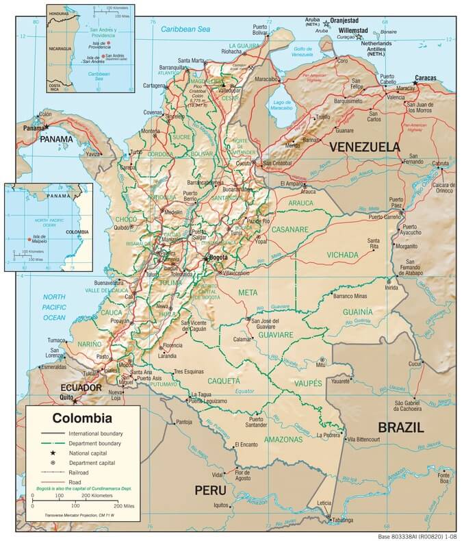
Colombia physiographic map
The Andean Spine: Three Mountain Chains Defining a Nation
The Andes Mountains form Colombia's most defining geographical feature, entering the country from Ecuador and dramatically splitting into three parallel cordilleras that stretch northward like enormous fingers. This tripartite division creates a complex topographical landscape that has fundamentally shaped Colombian civilization for millennia.
The Cordillera Occidental (Western Range) rises abruptly from the Pacific coastal plains, forming a formidable barrier between the interior and the coast. This range, while the narrowest of the three, contains some of Colombia's most rugged terrain, with peaks reaching over 4,000 m (13,123 ft). The Farallones de Cali, towering at 4,280 m (14,042 ft), dominate the skyline near the city of Cali. The western slopes receive intense Pacific moisture, creating some of the world's wettest environments, while the eastern slopes transition into the drier Cauca Valley. This cordillera's relative isolation has preserved significant biodiversity and Indigenous cultures, particularly among the Emberá and Wounaan peoples.
The Cordillera Central stands as Colombia's most volcanically active range, punctuated by numerous active and dormant volcanoes that have shaped both the landscape and human history. Nevado del Ruiz, at 5,321 m (17,457 ft), tragically demonstrated the range's volcanic power when it erupted in 1985, devastating the town of Armero. Other major peaks include Nevado del Tolima at 5,215 m (17,110 ft) and Nevado de Santa Isabel at 4,965 m (16,289 ft). The volcanic soils of this range have created some of Colombia's most fertile agricultural lands, particularly in the renowned Coffee Triangle, where the combination of altitude, climate, and soil composition produces some of the world's finest arabica coffee.
The Cordillera Oriental (Eastern Range) extends furthest north and east, forming the widest and most populous of the three ranges. This massive mountain system encompasses the Altiplano Cundiboyacense, a high plateau where Bogotá is situated at an elevation of 2,640 m (8,660 ft) above sea level. The plateau's relatively flat terrain and temperate climate have supported dense human settlement since pre-Columbian times. The range also contains the Sierra Nevada del Cocuy, with peaks exceeding 5,000 m (16,404 ft), including Ritacuba Blanco at 5,330 m (17,487 ft), one of Colombia's highest summits.
These mountain ranges create distinct inter-Andean valleys that serve as crucial agricultural and population centers. The Magdalena Valley, situated between the Central and Eastern cordilleras, serves as Colombia's primary transportation corridor and agricultural heartland. The Valle del Cauca, nestled between the Western and Central ranges, supports intensive sugar cultivation and livestock production.
The Caribbean Coast: Where History Meets the Sea
Colombia's Caribbean coastline extends approximately 1,760 km (1,094 mi) along the warm waters of the Caribbean Sea, creating a region of remarkable geographical and cultural diversity. This coastal zone encompasses everything from pristine beaches and coral reefs to mangrove swamps and desert landscapes, each supporting distinct ecosystems and human communities.
The western section of the coast features the Magdalena River Delta, where Colombia's primary river system meets the sea. This extensive wetland system, including the Ciénaga Grande de Santa Marta, which covers 4,280 km² (1,653 mi²), serves as a critical habitat for over 200 bird species and supports important fisheries. The delta's complex network of lagoons, marshes, and barrier islands creates a dynamic environment where freshwater and saltwater ecosystems intermingle.
Moving eastward, the Sierra Nevada de Santa Marta rises dramatically from the Caribbean coast, forming the world's highest coastal mountain range. This isolated massif reaches 5,775 m (18,947 ft) at Pico Cristóbal Colón, creating an extraordinary vertical ecosystem that ranges from tropical beaches to perpetual snow within just 42 km (26 mi) of each other. The Sierra Nevada's unique geography supports endemic species found nowhere else on Earth. It provides refuge for Indigenous groups, including the Kogui, Wiwa, and Arhuaco peoples, who consider the mountain sacred.
The coast's eastern extremity features the Guajira Peninsula, a semi-arid desert region that extends into Venezuela. This unique landscape receives less than 300 mm (12 in) of rainfall annually, supporting specialized desert vegetation and the Indigenous Wayuu people, who have adapted their pastoral lifestyle to the harsh environment. The peninsula's geography includes salt flats, coastal dunes, and flamingo-filled lagoons, creating surreal landscapes that contrast sharply with Colombia's rainforest regions.
Historically significant cities dot the Caribbean coast, each reflecting the region's complex geography and history. Cartagena, protected by natural bays and islands, became Spain's principal Caribbean port. Barranquilla, located at the mouth of the Magdalena River, developed as Colombia's primary commercial gateway. Santa Marta, situated between the Sierra Nevada and the sea, is the oldest surviving city in Colombia and a vital port for banana exports.
The Pacific Coast: Where Rainforest Meets Ocean
Colombia's Pacific coastline stretches approximately 1,300 kilometers (808 miles) through one of the world's most biodiverse and climatically extreme regions. This coast forms part of the Chocó Biogeographic Region, a narrow strip of land that experiences some of the heaviest rainfall on Earth—up to 13,000 mm (512 in) annually in some areas, with most locations receiving over 7,000 mm (275 in). This extraordinary precipitation creates a lush rainforest environment that extends from sea level to the foothills of the Andes.
The Chocó rainforest harbors exceptional biodiversity, with endemic species rates approaching 25% for some groups. The region's isolation, created by the Cordillera Occidental, has allowed unique evolutionary processes to occur, resulting in species found nowhere else on Earth. The forests contain over 9,000 plant species, including numerous palms, orchids, and bromeliads that thrive in the humid environment.
The coastline itself features a complex geography of mangrove swamps, rocky headlands, and black sand beaches formed from volcanic minerals. The Serranía del Baudó, a coastal mountain range reaching 1,810 m (5,938 ft), creates dramatic landscapes where mountains plunge directly into the Pacific. This range, geologically distinct from the main Andes, adds another layer of complexity to the region's topography.
Major river systems, including the Atrato, San Juan, and Patía rivers, drain the western slopes of the Cordillera Occidental, creating extensive floodplains and deltas. The Atrato River, in particular, flows through a broad valley that nearly bisects the continent, creating a natural corridor between the Pacific and Caribbean watersheds.
The Pacific coast serves as a crucial breeding ground for humpback whales, which migrate over 8,000 km (5,000 mi) from Antarctic feeding grounds to give birth in the warm waters between June and November. This migration represents one of the longest mammalian migrations on Earth and supports important eco-tourism industries.
The Orinoco Plains: Colombia's Eastern Frontier
East of the Andes, Colombia's landscape transforms dramatically into the vast Orinoco Basin, a region of seemingly endless grasslands and seasonal wetlands known as the Llanos. Covering approximately 250,000 square kilometers (96,525 square miles)—roughly the size of the United Kingdom—this region represents one of South America's great natural grasslands.
The Llanos experience a pronounced wet and dry season cycle that fundamentally shapes the landscape and ecosystems. During the wet season (May to October), vast areas flood, creating temporary wetlands that support enormous concentrations of wildlife. As the waters recede during the dry season, the plains transform into golden grasslands, dotted with gallery forests along the riverbanks.
This seasonal flooding creates one of the world's most productive freshwater ecosystems. The wetlands support over 70 fish species, including massive catfish that can weigh up to 100 kg (220 lbs). The grasslands teem with wildlife, including the world's largest rodent, the capybara, which can weigh up to 66 kg (145 lbs). Caimans, giant river otters, and hundreds of bird species, including the spectacular scarlet ibis, thrive in this environment.
The Orinoco River itself, one of South America's major waterways, forms part of Colombia's border with Venezuela. The river's tributaries, including the Meta, Vichada, and Guaviare rivers, create an extensive network of waterways that serve as transportation corridors for the sparsely populated region.
Economically, the Llanos support extensive cattle ranching operations, with some ranches covering areas larger than small countries. The region's grasslands can support up to 1.5 head of cattle per hectare during favorable seasons. Additionally, the Llanos contain significant oil reserves, particularly in the Cusiana and Cupiagua fields, which have become important to Colombia's energy sector.
The Amazon Basin: Colombia's Green Heart
Southern Colombia encompasses nearly 400,000 km² (154,440 mi²) of the Amazon Basin, representing approximately 35% of the country's territory. This vast rainforest region contains the headwaters of major Amazon tributaries and harbors biodiversity that scientists are still discovering and cataloging.
The Colombian Amazon differs significantly from the main Amazon River basin in Brazil. Much of the region consists of ancient geological formations, including the Guyana Shield, which gives rise to unique tepuis (table mountains) and distinctive ecosystems. The terrain ranges from lowland rainforests to highland plateaus, creating a diverse array of habitats within the broader Amazon ecosystem.
The region's river systems, including the Caquetá, Putumayo, and Vaupés rivers, flow eastward toward the Amazon River, creating vast floodplains and meandering channels. These rivers support pink river dolphins, giant river otters, and massive fish species, such as the pirarucu, which can reach lengths of 3 m (10 ft) and weights of 200 kg (440 lbs).
Indigenous communities maintain a profound connection to the Amazon landscape, with over 60 distinct ethnic groups calling the region home. Groups such as the Ticuna, Huitoto, and Nukak have developed a sophisticated understanding of forest ecology, using traditional knowledge to manage resources sustainably. Their territorial reserves cover significant portions of the Colombian Amazon, serving as crucial conservation areas.
The town of Leticia, situated on the Amazon River where Colombia, Brazil, and Peru meet, serves as the region's primary urban center. This strategic location makes it a hub for scientific research, eco-tourism, and conservation efforts. The surrounding area includes the Amacayacu National Park, which protects 2,930 km² (1,131 mi²) of pristine rainforest and supports research on Amazon ecology.
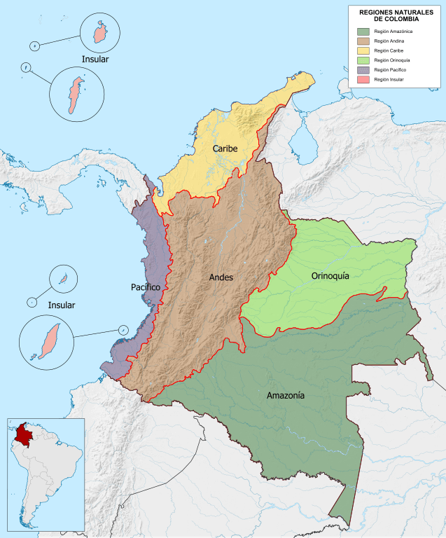
Map depicting the natural regions of Colombia.
Hydrological Wealth: Rivers as Lifelines
Colombia's river systems form the nation's circulatory system, providing water for agriculture, transportation, and energy production while supporting diverse aquatic ecosystems. The country's unique geography gives rise to three major watershed systems that drain into distinct bodies of water.
The Magdalena-Cauca system represents Colombia's most economically important watershed. The Magdalena River, stretching 1,528 km (949 mi) from its source in the Cordillera Oriental to its mouth at the Caribbean Sea, drains approximately 24% of Colombia's territory. The river's basin supports 77% of the country's population and generates 85% of its GDP. The Cauca River, the Magdalena's primary tributary, flows northward through the fertile valley between the Western and Central cordilleras, supporting intensive agriculture and multiple hydroelectric projects.
The Orinoco system drains the eastern plains through rivers such as the Meta, Vichada, and Guaviare. These rivers experience dramatic seasonal variations, with flow rates increasing by 500% or more during the wet season. The system supports important fisheries and provides transportation routes for remote communities.
The Amazon system in southern Colombia encompasses major tributaries, including the Caquetá, Putumayo, and Vaupés rivers. These rivers maintain relatively stable flows throughout the year due to the region's consistent rainfall patterns. The system supports extraordinary aquatic biodiversity, including over 3,000 fish species—more than the entire Atlantic Ocean.
Colombia's lakes and wetlands further enhance its hydrological wealth. The Laguna de la Cocha, at 2,760 m (9,055 ft) above sea level, represents one of the country's largest natural lakes and supports important trout fisheries. The Ciénaga de Zapatosa, Colombia's largest freshwater lake, serves as a critical habitat for migratory birds and supports local fishing communities.
Climate Zones and Biodiversity
Colombia's geographical diversity creates distinct climate zones that support an extraordinary biodiversity. The country's location near the equator, combined with its varied topography, produces environments ranging from tropical rainforests to alpine tundra, often within relatively short distances.
The tropical lowlands (0-1,000 m or 0-3,281 ft) experience consistently warm temperatures averaging 24-27°C (75-81°F) with high humidity. These zones support the country's most diverse ecosystems, including the Amazon rainforest, Caribbean dry forests, and Pacific coastal rainforests.
The subtropical zone (1,000-2,000 m or 3,281-6,562 ft) encompasses the coffee-growing regions and many of Colombia's major cities. Temperatures average 17-24°C (63-75°F), creating ideal conditions for agriculture and human habitation. This zone supports cloud forests, which harbor exceptional endemic species diversity.
The temperate zone (2,000-3,000 m or 6,562-9,843 ft) includes cities like Bogotá and supports unique ecosystems such as the Andean páramo. These high-altitude grasslands act as crucial water sources, capturing moisture from clouds and regulating water flow to lower elevations.
The alpine zone (above 3,000 m (9,843 ft) features páramo grasslands and, at the highest elevations, permanent snow. These environments support specialized plant and animal communities adapted to extreme conditions and serve as critical water reserves for the entire country.
This climatic diversity contributes to Colombia's status as one of the world's 17 megadiverse countries. The nation harbors over 56,000 described species, with scientists estimating that hundreds of thousands more remain undiscovered. Colombia leads the world in bird diversity, with over 1,900 species, and contains more orchid species than any other country, while also supporting the second-highest plant diversity globally.
Geographic Challenges and Opportunities
Colombia's remarkable geographical diversity presents both extraordinary opportunities and significant challenges. The varied landscapes support multiple economic sectors, including agriculture, mining, tourism, and energy production. However, the same topographical complexity that creates this diversity also poses infrastructure challenges and contributes to regional inequality.
The Andean topography creates natural barriers that have historically limited transportation and communication between regions. Building roads, railways, and communication networks across steep mountain terrain requires enormous investment and ongoing maintenance. These geographic challenges have contributed to regional isolation and uneven development patterns.
Climate change poses particular threats to Colombia's diverse ecosystems. Andean glaciers are retreating rapidly, posing a threat to water supplies for major cities and agricultural regions. Rising sea levels endanger coastal communities and ecosystems, while changing precipitation patterns could disrupt the delicate balance of seasonal flooding in the Llanos.
Conversely, Colombia's geographical position offers significant advantages for renewable energy development. The country's mountainous terrain provides excellent opportunities for hydroelectric power generation, while consistent trade winds along both coasts create potential for wind energy development. The intense solar radiation in highland regions could support the development of solar power.
The country's biodiversity represents both a global treasure and an economic opportunity. Well-managed eco-tourism, sustainable forestry, and bioprospecting for pharmaceutical compounds could provide significant financial benefits while preserving natural ecosystems.
Conclusion: A Geographic Tapestry
Colombia's geography represents one of nature's most complex and beautiful tapestries. From the snow-capped peaks of the Sierra Nevada de Santa Marta to the steaming rainforests of the Amazon, from the seasonal floods of the Llanos to the arid landscapes of the Guajira Peninsula, this nation encompasses an extraordinary range of environments within its borders.
This geographical diversity has profoundly shaped Colombian society, creating regional cultures adapted to specific landscapes while fostering national unity through shared challenges and opportunities. The interplay between mountains, rivers, forests, and coasts continues to influence everything from economic development and political organization to cultural expression and environmental conservation.
As Colombia moves forward in the 21st century, its geographical endowment remains both its greatest asset and its most significant challenge. Successfully managing this natural wealth while addressing the challenges of climate change, sustainable development, and environmental conservation will determine not only Colombia's future but also contribute to global efforts to preserve the planet's biodiversity and ecological integrity.
The story of Colombia is ultimately the story of its geography—a testament to the power of natural forces to create diversity, beauty, and complexity that continues to inspire wonder and demand thoughtful stewardship for future generations.